Great Amwell

Great Amwell
Great Amwell
Parroquia civil y pueblo del Reino Unido
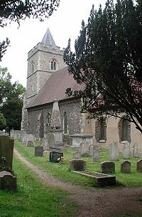
St John the Baptist, Great Amwell, Herts - geograph.org.uk - 348894.jpg
Iglesia de San Juan el Bautista, en Great Amwell.
Great Amwell
Great Amwell
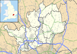
Ubicación de Great Amwell en Hertfordshire.
51°47′25.8″N 0°0′58.1″O / 51.7905, -0.016139Coordenadas: 51°47′25.8″N 0°0′58.1″O / 51.7905, -0.016139
Entidad Parroquia civil y pueblo
 • País Bandera del Reino Unido Reino Unido
 • Nación constitutiva Inglaterra
 • Región Este de Inglaterra
 • Condado Hertfordshire
 • Distrito East Hertfordshire
Superficie  
 • Total 3,03 km²
Población (2001)  
 • Total 2.239 hab.
 • Densidad 738,94 hab/km²
Huso horario GMT (UTC0)
 • en verano BST (UTC +1)
Código postal SG12
Prefijo telefónico 01920

Great Amwell es una parroquia civil y un pueblo del distrito de East Hertfordshire, en el condado de Hertfordshire (Inglaterra).

Contenido

Geografía

Según la Oficina Nacional de Estadística británica, Great Amwell tiene una superficie de 3,03 km².[1]

Demografía

Según el censo de 2001, Great Amwell tenía 2239 habitantes (47,48% varones, 52,52% mujeres) y una densidad de población de 738,94 hab/km². El 21,13% eran menores de 16 años, el 72,85% tenían entre 16 y 74, y el 6,03% eran mayores de 74. La media de edad era de 36,83 años. Del total de habitantes con 16 o más años, el 28,77% estaban solteros, el 57,47% casados, y el 13,76% divorciados o viudos.[2]

El 94,86% de los habitantes eran originarios del Reino Unido. El resto de países europeos englobaban al 2,28% de la población, mientras que el 2,86% había nacido en cualquier otro lugar. Según su grupo étnico, el 98,48% eran blancos, el 0,45% mestizos, el 0,13% asiáticos, el 0,54% negros, y el 0,27% chinos. El cristianismo era profesado por el 77,78%, el budismo por el 0,13%, el hinduismo por el 0,13%, el judaísmo por el 0,45%, el islam por el 0,31%, y cualquier otra religión, salvo el sijismo, por el 0,18%. El 14,59% no eran religiosos y el 6,43% no marcaron ninguna opción en el censo.[1]

Había 921 hogares con residentes, 19 vacíos, y 7 eran alojamientos vacacionales o segundas residencias.[2]

Referencias

  1. a b Tablas: «Usual Resident Population (KS01) for Amalgamated Parishes», «Ethnic Group (KS06) for Amalgamated Parishes», «Country of Birth (KS05) for Amalgamated Parishes» y «Religion (KS07) for Amalgamated Parishes», disponibles para descarga aquí. Office for National Statistics (inglés).
  2. a b «Area: Great Amwell CP (Parish)» (en inglés). Office for National Statistics. Consultado el 30 de octubre de 2011.

Enlaces externos


Wikimedia foundation. 2010.

Игры ⚽ Поможем решить контрольную работу

Mira otros diccionarios:

  • Amwell, Hertfordshire — infobox UK place country = England static static image caption= latitude= 51.80 longitude= 00.31 official name = Amwell population = shire district= shire county= Hertfordshire metropolitan borough= metropolitan county = region=East of England… …   Wikipedia

  • Amwell Township, New Jersey — Amwell Township was a Township that existed in Hunterdon County, New Jersey, United States, from 1708 to 1846.The Township was established by a royal patent on June 8, 1708, from Queen Anne, the first sovereign of the combined kingdom of Great… …   Wikipedia

  • Robert Mylne — Infobox Architect caption=Engraving of Mylne, aged 24, by Vincenzio Vangelisti, after a drawing by Richard Brompton. name=Robert Mylne nationality=Scottish birth date=4 January 1733 birth place=Edinburgh death date=5 May 1811 death place=Great… …   Wikipedia

  • Maurice Nicoll — Autres noms Martin Swayne Activités Médecin et écrivain Naissance 19 juillet 1884 Kelso, Ecosse, Royaume Uni Décès 30 août 1953 Great Amwell, R …   Wikipédia en Français

  • List of places in Hertfordshire — This is a list of settlements in the ceremonial county of Hertfordshire, England. See the list of places in England for places in other counties.compactTOC NOTOC A*Abbots Langley, Adeyfield, Albury, Aldbury, Aldenham, Amwell, Apsley, Ashridge,… …   Wikipedia

  • Hoddesdon — infobox UK place country = England latitude= 51.759 longitude= 0.015 official name= Hoddesdon population= 20,250 [cite web |url=http://www.hertsdirect.org/infobase/docs/pdfstore/tabKS01sett.pdf |title=Office for National Statistics, 2001 Census,… …   Wikipedia

  • Hardmead Lock — Infobox Waterlock lock name=Hardmead Lock waterway=River Lee Navigation operation=Manual maint=British Waterways county=Hertfordshire first= length=convert|85|ft|m|1|lk=on width=convert|16|ft|m|1 fall=convert|5|ft|6|in|1 enda=Bow Creek… …   Wikipedia

  • Ware — infobox UK place country = England official name= Ware latitude= 51.817 longitude= 0.029182 civil parish= Christ Church Ware and St Mary the Virgin Ware population= 18,000 shire district= East Hertfordshire shire county = Hertfordshire region=… …   Wikipedia

  • New River (England) — For other uses, see New River (disambiguation). The New Gauge House (1856) where water leaves the River Lea at the start of the New River The New River is an artificial waterway in England, opened in 1613 to supply London with fresh drinking… …   Wikipedia

  • William Chadwell Mylne — (April 1781 ndash; 25 December 1863) was a British engineer and architect. He was descended from a Scottish family of masons and architects, and was the second son of Robert Mylne (1733 1811), surveyor to the New River Company, and builder of the …   Wikipedia

Compartir el artículo y extractos

Link directo
Do a right-click on the link above
and select “Copy Link”