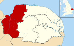
- King's Lynn and West Norfolk
-
King's Lynn and West Norfolk Distrito no metropolitano de Inglaterra 
Ubicación de King's Lynn and West Norfolk en el condado de Norfolk.Capital King's Lynn Idioma oficial Inglés Entidad Distrito no metropolitano • País  Inglaterra
• Región Este de Inglaterra • Condado Norfolk Superficie Puesto 12.º • Total 1,428.77 km²1,096% Población (2008) Puesto 127.º • Total 144,800 hab.0,28% • Densidad 101 hab/km² Sitio web oficial King's Lynn and West Norfolk es un distrito no metropolitano con el estatus de municipio ubicado en el condado de Norfolk, Inglaterra (Reino Unido). La sede del gobierno se ubica en la ciudad de King's Lynn.
Historia
En virtud de la Ley de Gobierno Local de 1972, el distrito fue creado en 1974 por la fusión del municipio de King's Lynn, los distritos urbanos de Hunstanton y Downham Market y los distritos rurales de Docking, Downham, Lynn Freebridge y Marshland. Originalmente, el distrito fue denominado como Norfolk Occidental. Adoptó su actual nombre en 1981.
Organización
El distrito está compuesto por el área urbana de King's Lynn y 102 parroquias. Según los datos del censo de 2001, el distrito tenía una superficie de 1.473 km²; de los cuales, 28 km² pertenecían al área urbana de King's Lynn y 1.445 km² a las parroquias que lo integran. En 2008 su población era de 144.800 hab.
Aparte de la ciudad de King's Lynn, que en sí no es un parroquia, el distrito comprende las parroquias civiles siguientes:
- Anmer
- Bagthorpe with Barmer, Barton Bendish, Barwick, Bawsey, Bircham, Boughton, Brancaster, Burnham Market, Burnham Norton, Burnham Overy, Burnham Thorpe
- Castle Acre, Castle Rising, Choseley, Clenchwarton, Congham, Crimplesham
- Denver, Dersingham, Docking, Downham Market, Downham West
- East Rudham, East Walton, East Winch, Emneth
- Feltwell, Fincham, Flitcham with Appleton, Fordham, Fring
- Gayton, Great Massingham, Grimston
- Harpley, Heacham, Hilgay, Hillington, Hockwold cum Wilton, Holme next the Sea, Houghton, Hunstanton
- Ingoldisthorpe
- Leziate, Little Massingham
- Marham, Marshland St. James, Methwold, Middleton
- Nordelph, North Creake, North Runcton, Northwold, North Wootton
- Old Hunstanton, Outwell
- Pentney
- Ringstead, Roydon, Runcton Holme, Ryston
- Sandringham, Sedgeford, Shernborne, Shouldham, Shouldham Thorpe, Snettisham, South Creake, Southery, South Wootton, Stanhoe, Stoke Ferry, Stow Bardolph, Stradsett, Syderstone
- Terrington St. Clement, Terrington St. John, Thornham, Tilney All Saints, Tilney St. Lawrence, Titchwell, Tottenhill
- Upwell
- Walpole, Walpole Cross Keys, Walpole Highway, Walsoken, Watlington, Welney, Wereham, West Acre, West Dereham, West Rudham, West Walton, West Winch, Wiggenhall St. Germans, Wiggenhall St. Mary Magdalen, Wimbotsham, Wormegay, Wretton
Categorías:- Distritos no metropolitanos de Norfolk
- Municipios de Inglaterra
Wikimedia foundation. 2010.
