Stone Rural

Stone Rural
Stone Rural
Parroquia civil del Reino Unido
Stone Rural
Stone Rural
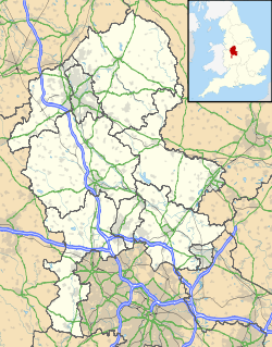
Ubicación de Stone Rural en Staffordshire.
52°55′29.1″N 2°8′8.6″O / 52.92475, -2.135722Coordenadas: 52°55′29.1″N 2°8′8.6″O / 52.92475, -2.135722
Entidad Parroquia civil
 • País Bandera del Reino Unido Reino Unido
 • Nación constitutiva Inglaterra
 • Región Midlands del Oeste
 • Condado Staffordshire
 • Distrito Stafford
Superficie  
 • Total 36,96 km²
Población (2001)  
 • Total 1.539 hab.
 • Densidad 41,64 hab/km²
Huso horario GMT (UTC0)
 • en verano BST (UTC +1)
Código postal ST15

Stone Rural es una parroquia civil del distrito de Stafford, en el condado de Staffordshire (Inglaterra).

Geografía

Según la Oficina Nacional de Estadística británica, Stone Rural tiene una superficie de 36,96 km².[1]

Demografía

Según el censo de 2001, Stone Rural tenía 1539 habitantes (48,02% varones, 51,98% mujeres) y una densidad de población de 41,64 hab/km². El 15,59% eran menores de 16 años, el 72,97% tenían entre 16 y 74, y el 11,44% eran mayores de 74. La media de edad era de 46,04 años. Del total de habitantes con 16 o más años, el 18,71% estaban solteros, el 66,74% casados, y el 14,55% divorciados o viudos.[2]

Según su grupo étnico, el 98,63% de los habitantes eran blancos, el 0,33% mestizos, el 0,65% asiáticos, el 0,2% chinos, y el 0,2% de cualquier otro salvo negros. La mayor parte (96,56%) eran originarios del Reino Unido. El resto de países europeos englobaban al 1,43% de la población, mientras que el 2,01% había nacido en cualquier otro lugar. El cristianismo era profesado por el 82,94%, el budismo por el 0,19%, el hinduismo por el 0,19%, el judaísmo por el 0,32%, el islam por el 0,71%, y cualquier otra religión, salvo el sijismo, por el 0,19%. El 8,82% no eran religiosos y el 6,61% no marcaron ninguna opción en el censo.[1]

Había 622 hogares con residentes y 28 vacíos.[2]

Referencias

  1. a b Tablas: «Usual Resident Population (KS01) for Amalgamated Parishes», «Ethnic Group (KS06) for Amalgamated Parishes», «Country of Birth (KS05) for Amalgamated Parishes» y «Religion (KS07) for Amalgamated Parishes», disponibles para descarga aquí. Office for National Statistics (inglés).
  2. a b «Area: Stone Rural CP (Parish)» (en inglés). Office for National Statistics. Consultado el 15 de octubre de 2011.

Wikimedia foundation. 2010.

Игры ⚽ Нужно решить контрольную?

Mira otros diccionarios:

  • Stone Rural District — infobox historic subdivision Name= Stone Rural District HQ= Status= Rural district Start= 1894 End= 1974 Replace= Borough of Stafford PopulationFirst= 13,959 PopulationFirstYear= 1901 PopulationLast= 22,144 PopulationLastYear= 1971 AreaFirst=… …   Wikipedia

  • Stone, Staffordshire — infobox UK place country = England official name= Stone latitude= 52.9 longitude= 2.15 population = 14,258 (2001 census) shire district= Stafford shire county= Staffordshire region= West Midlands constituency westminster= Stone post town= Stone… …   Wikipedia

  • Stone Bridge and the Oregon Central Military Wagon Road — Stone Bridge and Oregon Central Military Wagon Road U.S. National Register of Historic Places …   Wikipedia

  • Rural crafts — refers to the traditional crafts production that is carried on, simply for everyday practical use, in the agricultural countryside. Once widespread and commonplace, the survival of some rural crafts is now in doubtFact|date=July 2008.Not being… …   Wikipedia

  • Stone Age — the period in the history of humankind, preceding the Bronze Age and the Iron Age, and marked by the use of stone implements and weapons: subdivided into the Paleolithic, Mesolithic, and Neolithic periods. [1860 65] * * * First known period of… …   Universalium

  • Rural Township, Jefferson County, Kansas — Infobox Settlement official name = Rural Township settlement type = Township nickname = motto = imagesize = image caption = image imagesize = image caption = image mapsize = map caption = Location in Jefferson County mapsize1 = map caption1 =… …   Wikipedia

  • Stone Age Poland — The Stone Age era on the lands of today s Poland lasted five hundred thousand years and involved three different human species. The Stone Age cultures ranged from early human groups with primitive tools to advanced agricultural societies using… …   Wikipedia

  • Stone County, Mississippi — Infobox U.S. County county = Stone County state = Mississippi map size = 150 founded = 1916 seat = Wiggins | largest city = Wiggins | area total sq mi =448 area land sq mi =445 area water sq mi =3 area percentage = 0.60% census yr = 2000 pop =… …   Wikipedia

  • Stone Age Institute — The Stone Age Institute is an independent research center dedicated to the archaeological study of human origins and technological development. The institute conducts research and education in human origins studies, publishes books and articles,… …   Wikipedia

  • Basque rural sports — Basque rural sports, known as Herri Kirolak in Basque, is the term used for a number of sports competitions rooted in the traditional lifestyles of the Basque people. They are called deporte rural vasco or simply deportes vascos in Spanish and… …   Wikipedia

Compartir el artículo y extractos

Link directo
Do a right-click on the link above
and select “Copy Link”