Stretton (East Staffordshire, Staffordshire)

Stretton (East Staffordshire, Staffordshire)
Stretton
Parroquia civil y pueblo del Reino Unido
Stretton
Stretton
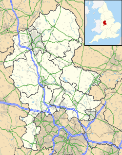
Ubicación de Stretton en Staffordshire.
52°50′2.1″N 1°37′33.4″O / 52.833917, -1.625944Coordenadas: 52°50′2.1″N 1°37′33.4″O / 52.833917, -1.625944
Entidad Parroquia civil y pueblo
 • País Bandera del Reino Unido Reino Unido
 • Nación constitutiva Inglaterra
 • Región Midlands del Oeste
 • Condado Staffordshire
 • Distrito East Staffordshire
Superficie  
 • Total 4,49 km²
Población (2001)  
 • Total 8.355 hab.
 • Densidad 1860,8 hab/km²
Huso horario GMT (UTC0)
 • en verano BST (UTC +1)
Código postal DE13
Prefijo telefónico 01283

Stretton es una parroquia civil y un pueblo del distrito de East Staffordshire, en el condado de Staffordshire (Inglaterra).

Contenido

Geografía

Según la Oficina Nacional de Estadística británica, Stretton tiene una superficie de 4,49 km².[1]

Demografía

Según el censo de 2001, Stretton tenía 8355 habitantes (48,7% varones, 51,3% mujeres) y una densidad de población de 1860,8 hab/km². El 21,39% eran menores de 16 años, el 72,77% tenían entre 16 y 74, y el 5,84% eran mayores de 74. La media de edad era de 38,13 años. Del total de habitantes con 16 o más años, el 20,75% estaban solteros, el 65,48% casados, y el 13,76% divorciados o viudos.[2]

Según su grupo étnico, el 98,01% de los habitantes eran blancos, el 0,41% mestizos, el 0,66% asiáticos, el 0,32% negros, el 0,38% chinos, y el 0,18% de cualquier otro. La mayor parte (97,38%) eran originarios del Reino Unido. El resto de países europeos englobaban al 0,93% de la población, mientras que el 1,69% había nacido en cualquier otro lugar. El cristianismo era profesado por el 82,78%, el budismo por el 0,19%, el hinduismo por el 0,26%, el islam por el 0,35%, el sijismo por el 0,06%, y cualquier otra religión, salvo el judaísmo, por el 0,07%. El 10,5% no eran religiosos y el 5,78% no marcaron ninguna opción en el censo.[1]

Había 3366 hogares con residentes, 102 vacíos, y 6 eran alojamientos vacacionales o segundas residencias.[2]

Referencias

  1. a b Tablas: «Usual Resident Population (KS01) for Amalgamated Parishes», «Ethnic Group (KS06) for Amalgamated Parishes», «Country of Birth (KS05) for Amalgamated Parishes» y «Religion (KS07) for Amalgamated Parishes», disponibles para descarga aquí. Office for National Statistics (inglés).
  2. a b «Area: Stretton CP (Parish)» (en inglés). Office for National Statistics. Consultado el 16 de septiembre de 2011.

Enlaces externos


Wikimedia foundation. 2010.

Игры ⚽ Поможем написать реферат

Mira otros diccionarios:

  • Staffordshire — Geographie Status: Zeremonielle und Verwaltungsgrafschaft Region: West Midlands Fläche: 2.713 Quadratkilometer …   Deutsch Wikipedia

  • Stretton — In England existieren mehrere Orte namens Stretton: Stretton (Derbyshire) im Distrikt North East Derbyshire in der Grafschaft Derbyshire Stretton (Rutland) in der Unitary Authority Rutland Stretton (Staffordshire) im Distrikt East Staffordshire… …   Deutsch Wikipedia

  • Stretton, Burton upon Trent, Staffordshire — infobox UK place country = England latitude= 52.834 longitude= 1.626 official name= Stretton shire district= East Staffordshire shire county=Staffordshire region= West Midlands constituency westminster= Burton post town= BURTON ON TRENT postcode… …   Wikipedia

  • Stretton — El topónimo Stretton puede hacer referencia a varios lugares de Inglaterra: Stretton, una parroquia civil y un pueblo en el condado de Derbyshire; dos pueblos en el condado de Staffordshire: Stretton, en el distrito de East Staffordshire;… …   Wikipedia Español

  • List of civil parishes in Staffordshire — This is a list of civil parishes in Staffordshire, England. Stoke on Trent is included in this list (though it is entirely unparished). =Cannock Chase= Cannock is unparished.* Brereton and Ravenhill * Bridgtown * Brindley Heath * Cannock Wood *… …   Wikipedia

  • High Sheriff of Staffordshire — This is a list of the High Sheriffs of Staffordshire.The High Sheriff is the oldest secular office under the Crown. Formerly the High Sheriff was the principal law enforcement officer in the county but over the centuries most of the… …   Wikipedia

  • Dunston, Staffordshire — Dunston village sign, May 2008 Dunston is a small village in England lying on the west side of the A449 trunk road about 3 miles (4.8 km) south of Stafford, close to Junction 13 of the M6 motorway. It lies at roughly 300 feet (98 m) above… …   Wikipedia

  • GNR Derbyshire and Staffordshire Extension — Legend Cross Country Route …   Wikipedia

  • St Mary's, Stretton — Parish church name = St Mary s, Stretton caption = dedication = denomination = Church of England tradition = diocese = Diocese of Lichfield province = Province of Canterbury vicar = Rev Kim Thomas curate = curate1 = organistdom = organist =… …   Wikipedia

  • GB-STS — Staffordshire Geographie Status: Zeremonielle und Verwaltungsgrafschaft Region: West Midlands …   Deutsch Wikipedia

Compartir el artículo y extractos

Link directo
Do a right-click on the link above
and select “Copy Link”