Castrop-Rauxel

Castrop-Rauxel

Castrop-Rauxel

Castrop-Rauxel
Bandera de Castrop-Rauxel
Bandera
Escudo de Castrop-Rauxel
Escudo
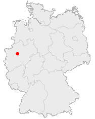
Lage der Stadt Castrop-Rauxel in Deutschland.png
País Flag of Germany.svg Alemania
• Estado Renania del Norte-
Westfalia
• Región Münster
• Distrito Recklinghausen
Ubicación 51°33′N 7°19′E / 51.55, 7.317
• Altitud 75 m msnm
Superficie 111,99 km² km²
Fundación 834
Población 77.780 hab., 2005 hab.
• Densidad 1.506 hab./km² hab./km²
Gentilicio none
Código postal 44575-44581
(antiguo: 4620)
Alcalde Johannes Beisenherz (SPD)
Sitio web www.castrop-rauxel.de

Castrop-Rauxel es una ciudad en el estado alemán de Renania del Norte-Westfalia. Es parte del Distrito de Recklinghausen y cuenta con casi 78.000 habitantes.

Contenido

Historia

Castrop-Rauxel fue mencionada por primera vez en 834 como Villa Castorpe, y recibió los derechos de Ciudad Imperial Libre en 1384. Ha existido en su forma actual desde 1975.

Alvar Aalto diseño el centro de la ciudad.

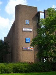
Ayuntamiento de Castrop-Rauxel

Geografía

Castrop-Rauxel esta situada en la region de Emscherland, en la parte norte del territorio del Ruhr y esta incluida en el distrito de la ciudad de Recklinghausen de la Región Rin-Ruhr.

La ciudad esta dividida en 15 barrios.

Economía

En años recientes Castrop-Rauxel vio crecer el fenomeno del “hombre de las palmeras”, quien fundó su negocio online de plantas exóticas.[1]

Referencias

  1. «El hombre de las palmeras: vendedor profesional por Internet» (en español). Deutsche Welle 27.07.2007 (2007). Consultado el 21/12/2007.

Véase también

Enlaces externos

Obtenido de "Castrop-Rauxel"

Wikimedia foundation. 2010.

Игры ⚽ Нужно решить контрольную?

Mira otros diccionarios:

  • Castrop-Rauxel — Castrop Rauxel …   Wikipédia en Français

  • Castrop-Rauxel — Wappen Deutschlandkarte …   Deutsch Wikipedia

  • Castrop Rauxel — Wappen Deutschlandkarte …   Deutsch Wikipedia

  • Castrop-Rauxel — Infobox German Location Art = Stadt Name = Castrop Rauxel Wappen = Stadtwappen der Stadt Castrop Rauxel.svg lat deg = 51 |lat min = 33 lon deg = 7 |lon min = 19 Lageplan = Bundesland = Nordrhein Westfalen Regierungsbezirk = Münster Kreis =… …   Wikipedia

  • Castrop-Rauxel — Ger. /kah strddawp rddowk seuhl/, n. a city in central North Rhine Westphalia, in W Germany. 81,900. Also, Kastrop Rauxel. * * * ▪ Germany       city, North Rhine–Westphalia Land (state), northwestern Germany. It lies near the Rhine Herne Canal,… …   Universalium

  • Castrop-Rauxel — Original name in latin Castrop Rauxel Name in other language Castrop Rauxel, Kastrop Rauksel, Kastrop Rauksel , Stadt Castrop Rauxel, ZCM, ka si te luo pu lao ke sai er, kastrwp rawksl, Кастроп Рауксел, Кастроп Рауксель, State code DE… …   Cities with a population over 1000 database

  • Castrop-Rauxel Hbf — im Zentrum von Rauxel Bahnhof Castrop Rauxel Süd im Zentrum von Castrop …   Deutsch Wikipedia

  • Castrop-Rauxel Hauptbahnhof — Empfangsgebäude mit Bahnhofsvorplatz Daten Kategorie 4 …   Deutsch Wikipedia

  • Castrop-Rauxel Hauptbahnhof — Hbf intro|Castrop Rauxel is the Hauptbahnhof of the German city Castrop Rauxel. It is situated on the S2 line of the Rhine Ruhr S Bahn.###@@@KEYEND@@@### …   Wikipedia

  • Castrop-Rauxel-Merklinde — DMS …   Deutsch Wikipedia

Compartir el artículo y extractos

Link directo
Do a right-click on the link above
and select “Copy Link”