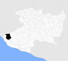
- Chinicuila
-
Chinicuila Municipio de México 
• Latitud 18° 45' • Longitud 103° 22' Entidad Municipio • País  México
• Estado  Michoacán
• Cabecera Villa Victoria Pdte. municipal Prof. Jesús Preciado Marmolejo • Fundación 1830 Superficie • Total 1.021,92 km² Altitud • Máxima 630 msnm Población • Total 5.271 hab. • Densidad Expresión errónea: carácter de puntuación "." desconocido hab/km² Gentilicio Chinicuilense Código postal 60823 Código INEGI 026 Sitio web oficial Chinicuila es un municipio del estado de Michoacán, México que fue fundado aproximadamente en 1830. En 1901 se le dio carácter de municipalidad por el gobierno estatal dándole el mismo nombre a su cabecera, años más tarde en 1923 por petición de los habitantes se le nombra a la cabecera del municipio de Chinicuila del Oro Villa Victoria.
Chuinicuila colinda en la parte norte con el estado de Jalisco, al este con el municipio de Coalcomán, al sur con Aquila y al oeste con Coahuayana y con el estado de Colima. El mapa general de la República Mexicana indica que dicho municipio se encuentra entre las coordenadas geográficas 18° 45' latitud norte y entre 103° 22' longitud oeste a a una altura promedio de 680 metros sobre el nivel del mar.
Religión En su mayoría la población es católica, aunque también hay evangelistas. Educación Este municipio cuenta con varios centros de educación preescolar, escuelas primarias, una escuela secundaria, tres telesecundarias y una preparatoria. Salud Existen 5 clínicas IMSS-Solidaridad y un Centro de Salud tipo “C” en la cabecera municipal.
Vías de comunicación
La cabecera municipal está comunicada por carretera pavimentada, mediante un ramal de la carretera Coalcomán-El Mar y a Colima por el tramo carretero de Villa Victoria-Paso de Potrerillos, a Coahuayana por el de Villa Victoria-Palos Marías y a las comunidades por medio de caminos de terracería. Cuenta con dos casetas telefónicas, una oficina de correos, una oficina de telégrafos y una caseta de radio comunicación del Gobierno del Estado, cuenta también con telefonía rural en algunas localidades.
Referencias
Categorías:- Localidades de Michoacán
- Municipios de Michoacán
Wikimedia foundation. 2010.
