- Harrow on the Hill
-
Harrow on the Hill Condado del Reino Unido 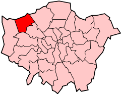
Entidad Condado • País  Reino Unido
• País cons.  Inglaterra
• Región Londres Población (2001) • Total 10,632 hab. • Densidad 29,74 hab/km² Harrow on the Hill es un área del noroeste de Londres, Inglaterra, y parte del distrito de Harrow del Gran Londres. Se ubica al sur de este distrito.[1] El nombre se refiere a la colina presente en la ciudad.[2]
Contenido
Etimología
La primera vez que se utilizó el nombre fue en 1398 como Harrowe atte Hille. La etimología antes de entonces deriva de Harrow, lo cual se mencionó por primera vez en 767 como Gumeninga hergae. Un significado posible es templo de una tribu llamada Gumeninga. La colina ha sido utilizada históricamente como un lugar de cultos paganos.[2] También tiene un significado alternativo, la iglesia sobre la colina.[3]
Historia
Harrow on the Hill formó una antigua parroquia y luego una parroquia civil en Middlesex.[4] En 1831 tenía una población de 3.861 personas y ocupaba un área de 9870 hectáreas. Hubo cambios de límites significativos en 1894, cuando la mayor parte de la parroquia fue removida para crear las iglesias de Harrow Weald, Wealdstone y Wembley.[4] Para 1931 ocupaba un área reducida de 2.129 hectáreas y tenía una población de 26.380 personas. Comenzó a formar parte del Distrito Urbano de Middlesex en 1894, lo cual fue abolido en 1934,[5] con la mayor parte del área conformando una parroquia civil y el distrito urbano de Harrow. En 1954 el distrito urbano fue incorporado como el Municipio de Harrow y en 1965 fue transferido a Londres, para formar el Municipio de Harrow de Londres.
Demografía
La población de Harrow on the Hill era de 9.578 personas en 1991 y de 10.632 en 2001. Ocupa un área de 357 hectáreas y en 2001 tuvo una densidad de población de 29,74 personas por hectárea. Hay 4.539 hogares en el distrito para 2001.[6] La colina abarca también Roxeth, Sudbury Hill y parte de West Harrow.
Religión
Harrow on the Hill es también una parroquia eclesiástica. La iglesia que se encuentra sobre la colina es la Catedral de St Mary, Harrow on the Hill. Fue fundada por San Anselmo en 1094.[7] En el área se encuentran, además, cuatro escuelas católicas y tres de la Iglesia de Inglaterra.
Universidad
Harrow on the Hill cuenta con un campus universitario que pertenece a la Universidad de Westminster (University of Westminster en inglés) conocido como Harrow Hall, donde, además, se realizan campamentos veraniegos.[8]
Referencias
- ↑ Harrow London Borough Council - Harrow on the Hill Village Conservation Area
- ↑ a b Mills, A., Dictionary of London Place Names, (2001)
- ↑ Harrow on the Hill, The Environs of London: volumen 2: County of Middlesex, (1795). Consultado el 10 de noviembre de 2008.
- ↑ a b Visión de Gran Bretaña - Harrow on the Hill parish (mapa histórico)
- ↑ Vision of Britain - Harrow on the Hill UD
- ↑ Harrow London Borough Council - 2001 Censo: Harrow on the Hill
- ↑ Church of St Mary, Harrow on the Hill
- ↑ «Harrow Hall».
Categoría:- Barrios de Londres

Wikimedia foundation. 2010.