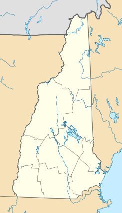
Hale's Location

Hale's Location
Hale's Location
Municipio de los Estados Unidos
Hale's Location
Hale's Location
Ubicación en el condado de Carroll en Nuevo Hampshire
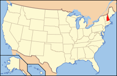
Ubicación de Nuevo Hampshire en EE. UU.
44°2′19″N 71°10′17″O / 44.03861, -71.17139Coordenadas: 44°2′19″N 71°10′17″O / 44.03861, -71.17139
Entidad Municipio
 • País Bandera de los Estados Unidos Estados Unidos
 • Estado Flag of New Hampshire.svg Nuevo Hampshire
 • Condado Carroll
Superficie  
 • Total 6,43 km²
 • Tierra 6,43 km²
 • Agua (0%) 0 km²
Altitud  
 • Media 184 msnm
Población (2010)  
 • Total 120 hab.
 • Densidad 18,67 hab/km²
Huso horario Este: UTC-5
 • en verano UTC-4
Código de área 603
GNIS 871993[1]

Hale's Location es un municipio ubicado en el condado de Carroll en el estado estadounidense de Nuevo Hampshire. En el año 2010 tenía una población de 120 habitantes y una densidad poblacional de 18,67 personas por km².[2]

Contenido

Geografía

Hale's Location se encuentra ubicado en las coordenadas 44°2′19″N 71°10′17″O / 44.03861, -71.17139. Según la Oficina del Censo de los Estados Unidos, el municipio tiene una superficie total de 6.43 km², de la cual 6.43 km² corresponden a tierra firme y (0%) 0 km² es agua.[3]

Demografía

Según el censo de 2010,[4] había 120 personas residiendo en Hale's Location. La densidad de población era de 18,67 hab./km². De los 120 habitantes, Hale's Location estaba compuesto por el 100% blancos, el 0% eran afroamericanos, el 0% eran amerindios, el 0% eran asiáticos, el 0% eran isleños del Pacífico, el 0% eran de otras razas y el 0% pertenecían a dos o más razas. Del total de la población el 0% eran hispanos o latinos de cualquier raza.[5]

Referencias

  1. «Sistema de Información de Nombres Geográficos: Hale's Location». Geographic Names Information System (en inglés) Consultado el 21 de noviembre de 2011.
  2. «U.S. Gazetteer: Censo de 2010» (en inglés). Oficina del Censo de los Estados Unidos (16 de febrero de 2011). Consultado el 11 de julio de 2011.
  3. «Encuentra un condado» (en inglés). Asociación Nacional de Condados (11 de julio de 2011). Consultado el 11 de julio de 2011.
  4. «American FactFinder» (en inglés). Oficina del Censo de los Estados Unidos. Consultado el 11 de julio de 2011.
  5. «US Board on Geographic Names» (en inglés). Servicio Geológico de los Estados Unidos (25 de octubre de 2007). Consultado el 11 de julio de 2011.

Enlaces externos


Wikimedia foundation. 2010.

Игры ⚽ Нужно решить контрольную?

Mira otros diccionarios:

  • Hale's Location, New Hampshire — Hale s Location is a township in Carroll County, New Hampshire, United States. The population was 58 at the 2000 census. In New Hampshire, locations, grants, townships (which are different from towns), and purchases are unincorporated portions of …   Wikipedia

  • Hale Common — is a farming hamlet on the Isle of Wight. Hale Common is on the A3056 road between Lake and Arreton. Hale Common is northeast of Bathingbourne and northwest of Branstone. Overview Hale Common features The Fighting Cocks pub. [… …   Wikipedia

  • Hale Duck Decoy — is a duck decoy located near to the village of Hale, in Halton, Cheshire, England. It is a Scheduled Ancient Monument, owned by Hale Estates and administered by Halton Borough Council.cite web |url=… …   Wikipedia

  • Hale Farm & Village — is a historic property of the Western Reserve Historical Society in Bath Township, Summit County, Ohio, United States. It is within the boundaries of the Cuyahoga Valley National Park. Hale Farm was the original homestead of Jonathan Hale a… …   Wikipedia

  • Hale's Ales — is a brewer of craft beers based in Seattle, Washington. It was founded by Mike Hale in 1983 in Colville, Washington. Its second brewery opened four years later in Kirkland, Washington. The Colville brewery moved to Spokane, Washington, in 1992,… …   Wikipedia

  • Hale, Utah — Hale is a ghost town in Carbon County, Utah. The site lies just to the east of Scofield Reservoir, at an elevation of 7598 feet (2316 meters). [gnis|1435642|Hale] In fact, the reservoir covers the upper part of town. Like the other nearby towns… …   Wikipedia

  • Hale — Hale, MO U.S. city in Missouri Population (2000): 473 Housing Units (2000): 222 Land area (2000): 0.550106 sq. miles (1.424768 sq. km) Water area (2000): 0.000000 sq. miles (0.000000 sq. km) Total area (2000): 0.550106 sq. miles (1.424768 sq. km) …   StarDict's U.S. Gazetteer Places

  • Hale Center — Hale Center, TX U.S. city in Texas Population (2000): 2263 Housing Units (2000): 885 Land area (2000): 1.086720 sq. miles (2.814591 sq. km) Water area (2000): 0.000000 sq. miles (0.000000 sq. km) Total area (2000): 1.086720 sq. miles (2.814591 sq …   StarDict's U.S. Gazetteer Places

  • Hale Center, TX — U.S. city in Texas Population (2000): 2263 Housing Units (2000): 885 Land area (2000): 1.086720 sq. miles (2.814591 sq. km) Water area (2000): 0.000000 sq. miles (0.000000 sq. km) Total area (2000): 1.086720 sq. miles (2.814591 sq. km) FIPS code …   StarDict's U.S. Gazetteer Places

  • Hale, MO — U.S. city in Missouri Population (2000): 473 Housing Units (2000): 222 Land area (2000): 0.550106 sq. miles (1.424768 sq. km) Water area (2000): 0.000000 sq. miles (0.000000 sq. km) Total area (2000): 0.550106 sq. miles (1.424768 sq. km) FIPS… …   StarDict's U.S. Gazetteer Places

Compartir el artículo y extractos

Link directo
Do a right-click on the link above
and select “Copy Link”