Trambileno

Trambileno
Trambileno
Trambileno
Trambileno
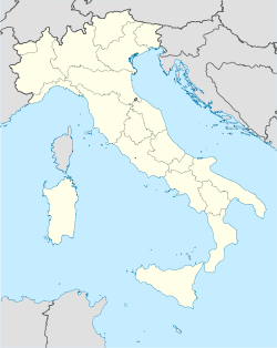
Localización de Trambileno en Italia
País Bandera de Italia Italia
• Región Coat of arms of Trentino-South Tyrol.svg Trentino-Alto Adigio
• Provincia Trento
Ubicación 45°52′0″N 11°4′0″E / 45.86667, 11.06667Coordenadas: 45°52′0″N 11°4′0″E / 45.86667, 11.06667
• Altitud 525 msnm
Superficie 50 km²
Fracciones Accheni, Boccaldo, Ca' Bianca, Clocchi, Dosso, Giazzera, Lesi, Moscheri (sede comunal), Pian della Lepre, Porte, Pozza, Pozzacchio, Rocchi, San Colombano, Sega, Spino, Toldo, Vanza, Vignala
Municipios limítrofes Posina (VI), Rovereto, Terragnolo, Vallarsa, Valli del Pasubio (VI)
Población 1.386[1] hab. (30-06-2008 (ISTAT))
• Densidad 27,7 hab./km²
Código postal 38068
Pref. telefónico 0464
Alcalde Stefano Bisoffi
Código ISTAT 022203
Cód. catastral L322
Sitio web Página web oficial

Trambileno es una localidad y comune italiana de la provincia de Trento, región de Trentino-Alto Adigio, con 1.386 habitantes.

Evolución demográfica

Censo de habitantes

Referencias

  1. Datos proporcionados por el Istituto Nazionale di Statistica. Datos demográficos (2009)

Enlaces externos


Wikimedia foundation. 2010.

Игры ⚽ Поможем решить контрольную работу

Mira otros diccionarios:

  • Trambileno — Administration Pays  Italie Région …   Wikipédia en Français

  • Trambileno — Infobox CityIT img coa = official name = Trambileno name = Trambileno region = Trentino Alto Adige/Südtirol province = Trento (TN) elevation m = 525 area total km2 = 50.3 population as of = Dec. 2004 population total = 1309 population density km2 …   Wikipedia

  • Trambileno — Original name in latin Trambileno Name in other language State code IT Continent/City Europe/Rome longitude 45.8689 latitude 11.07338 altitude 515 Population 1212 Date 2012 02 15 …   Cities with a population over 1000 database

  • Трамбилено — Коммуна Трамбилено Trambileno Страна ИталияИталия …   Википедия

  • Leno (stream) — For other meanings, see Leno. The Leno is the last of the main tributaries of the Adige river, at a confluence on its left bank near the town of Rovereto. It is actually formed of 2 water courses: *the Leno of Vallarsa (what is properly called… …   Wikipedia

  • Liste deutscher Bezeichnungen italienischer Orte — Für geographische Objekte (menschliche Siedlungen, Landschaften, Fluren, Berge, Flüsse usw.) auf dem heutigen Staatsgebiet Italiens existieren vielfach deutsche Namen. Zum einen, weil ein Teil des deutschen Sprachgebiets und einige deutsche… …   Deutsch Wikipedia

  • Rovereto — Pour les articles homonymes, voir Rovereto (homonymie).  Pour l’article homophone, voir Roveredo. Rovereto Administration …   Wikipédia en Français

  • Terragnolo — Administration Pays  Italie Région …   Wikipédia en Français

  • Vallarsa — Administration Pays  Italie Région …   Wikipédia en Français

  • Municipalities of Trentino — The following is a list of municipalities of the autonomous province of Trentino in northern Italy. Trentino is divided into 223 administrative subdivisions (Comuni/Gemeinden). Some municipalities have a second official language such as German… …   Wikipedia

Compartir el artículo y extractos

Link directo
Do a right-click on the link above
and select “Copy Link”