Wombourne

Wombourne
Wombourne
Parroquia civil y pueblo del Reino Unido

Wombourne Civic Offices.jpg
Oficinas del Ayuntamiento de Wombourne.
Wombourne
Wombourne
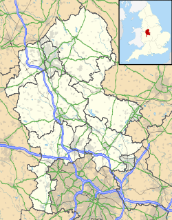
Ubicación de Wombourne en Staffordshire.
52°32′0.7″N 2°11′35.7″O / 52.533528, -2.19325Coordenadas: 52°32′0.7″N 2°11′35.7″O / 52.533528, -2.19325
Entidad Parroquia civil y pueblo
 • País Bandera del Reino Unido Reino Unido
 • Nación constitutiva Inglaterra
 • Región Midlands del Oeste
 • Condado Staffordshire
 • Distrito South Staffordshire
Superficie  
 • Total 11,84 km²
Población (2001)  
 • Total 13 691 hab.
 • Densidad 1156,33 hab/km²
Huso horario GMT (UTC0)
 • en verano BST (UTC +1)
Código postal WV5
Prefijo telefónico 01902

Wombourne es una parroquia civil y un pueblo del distrito de South Staffordshire, en el condado de Staffordshire (Inglaterra).

Contenido

Geografía

Según la Oficina Nacional de Estadística británica, Wombourne tiene una superficie de 11,84 km².[1]

Demografía

Según el censo de 2001, Wombourne tenía 13 691 habitantes (49,21% varones, 50,79% mujeres) y una densidad de población de 1156,33 hab/km². El 18,17% eran menores de 16 años, el 74,09% tenían entre 16 y 74, y el 7,74% eran mayores de 74. La media de edad era de 41,73 años. Del total de habitantes con 16 o más años, el 22,26% estaban solteros, el 62,88% casados, y el 14,85% divorciados o viudos.[2]

Según su grupo étnico, el 98,84% de los habitantes eran blancos, el 0,46% mestizos, el 0,48% asiáticos, el 0,05% negros, el 0,11% chinos, y el 0,06% de cualquier otro. La mayor parte (97,94%) eran originarios del Reino Unido. El resto de países europeos englobaban al 0,91% de la población, mientras que el 1,15% había nacido en cualquier otro lugar. El cristianismo era profesado por el 86,08%, el budismo por el 0,05%, el hinduismo por el 0,14%, el judaísmo por el 0,06%, el islam por el 0,05%, el sijismo por el 0,23%, y cualquier otra religión por el 0,12%. El 8,13% no eran religiosos y el 5,14% no marcaron ninguna opción en el censo.[1]

Había 5591 hogares con residentes, 77 vacíos, y 8 eran alojamientos vacacionales o segundas residencias.[2]

Referencias

  1. a b Tablas: «Usual Resident Population (KS01) for Amalgamated Parishes», «Ethnic Group (KS06) for Amalgamated Parishes», «Country of Birth (KS05) for Amalgamated Parishes» y «Religion (KS07) for Amalgamated Parishes», disponibles para descarga aquí. Office for National Statistics (inglés).
  2. a b «Area: Wombourne CP (Parish)» (en inglés). Office for National Statistics. Consultado el 11 de septiembre de 2011.

Enlaces externos


Wikimedia foundation. 2010.

Игры ⚽ Поможем сделать НИР

Mira otros diccionarios:

  • Wombourne — Infobox UK place country = England official name= Wombourne static static image caption=Wombourne Civic Offices latitude= 52.530223 longitude= 2.185692 population = 13,691 (2001 Census) shire district= South Staffordshire region= West Midlands… …   Wikipedia

  • Wombourne Branch Line — The Wombourne Branch Line was a railway situated in Central England. The line branched from the Oxford Worcester Wolverhampton Line at Kingswinford Junction to the north of Brettell Lane railway station and joined track at the triangular Oxley… …   Wikipedia

  • Brettell Lane railway station — Coordinates: 52°28′25″N 2°8′13″W / 52.47361°N 2.13694°W / 52.47361; 2.13694 …   Wikipedia

  • List of bus routes in the West Midlands county — A map which shows the area these routes operate in. This is a list of all the Network West Midlands bus routes in the West Midlands, England. Contents 1 …   Wikipedia

  • Kingswinford Junction — is a railway junction on the old Oxford Worcester Wolverhampton Line (OWW), which allows trains to diverge on to the Wombourne Branch Line. It is located north of Brettell Lane railway station, just before the line passes through Moor Street… …   Wikipedia

  • Staffordshire Club Cricket Championship — The Staffordshire Club Cricket Championship is the main cricket league in South Staffordshire. HistoryThe club s history goes back to 1975, and it has acted as a feeder league to the Birmingham and District Premier League since 1999.Division 1… …   Wikipedia

  • Smestow Valley Leisure Ride — starts at Aldersley Leisure Village in Aldersley and follows the route of the disused Wombourne Branchline to the disused Wombourne railway station. From Wombourne station, the route follows the Staffordshire and Worcestershire Canal back to… …   Wikipedia

  • Wombourn railway station — Infobox UK disused station name = Wombourn gridref = SO869939 caption = manager = Great Western Railway locale = Wombourne borough = South Staffordshire, Staffordshire platforms = 2 years = 1925 events = Station opened years2 = 1932 events2 =… …   Wikipedia

  • National Express West Midlands and Central Connect Diamond routes 254 and 255 — Infobox West Midlands Buses number=254, 255 operator=254 – National Express West Midlands (NXWM), 255 – NXWM, Diamond Bus (DIA) garage=NXWM – Wolverhampton/DIA Tividale vehicle=NXWM – Volvo B10, Volvo B6, Alexander Dennis ALX400, Transbus… …   Wikipedia

  • Dudley — For the larger local government district, see Metropolitan Borough of Dudley. For other uses, see Dudley (disambiguation). Coordinates: 52°30′43″N 2°05′45″W /  …   Wikipedia

Compartir el artículo y extractos

Link directo
Do a right-click on the link above
and select “Copy Link”