Hunting Valley (Ohio)

Hunting Valley (Ohio)
Hunting Valley
Villa de los Estados Unidos
Hunting Valley
Hunting Valley
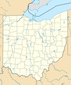
Ubicación en el condado de Cuyahoga en Ohio
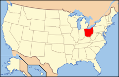
Ubicación de Ohio en EE. UU.
41°29′4″N 81°24′46″O / 41.48444, -81.41278Coordenadas: 41°29′4″N 81°24′46″O / 41.48444, -81.41278
Entidad Villa
 • País Bandera de los Estados Unidos Estados Unidos
 • Estado Bandera de Ohio Ohio
 • Condado Cuyahoga
Superficie  
 • Total 20,75 km²
 • Tierra 20,44 km²
 • Agua (1,51%) 0,31 km²
Altitud  
 • Media 294 msnm
Población (2010)  
 • Total 705 hab.
 • Densidad 33,97 hab/km²
Huso horario Este: UTC-5
 • en verano UTC-4
Código ZIP 44022
Código de área 440 - 216
GNIS 1085973[1]

Hunting Valley es una villa ubicada en el condado de Cuyahoga en el estado estadounidense de Ohio. En el Censo de 2010 tenía una población de 705 habitantes y una densidad poblacional de 33,97 personas por km².[2]

Contenido

Geografía

Hunting Valley se encuentra ubicada en las coordenadas 41°29′4″N 81°24′46″O / 41.48444, -81.41278. Según la Oficina del Censo de los Estados Unidos, Hunting Valley tiene una superficie total de 20.75 km², de la cual 20.44 km² corresponden a tierra firme y (1.51%) 0.31 km² es agua.[3]

Demografía

Según el censo de 2010,[4] había 705 personas residiendo en Hunting Valley. La densidad de población era de 33,97 hab./km². De los 705 habitantes, Hunting Valley estaba compuesto por el 97.02% blancos, el 0.57% eran afroamericanos, el 0% eran amerindios, el 1.13% eran asiáticos, el 0% eran isleños del Pacífico, el 0.28% eran de otras razas y el 0.99% pertenecían a dos o más razas. Del total de la población el 2.7% eran hispanos o latinos de cualquier raza.[5]

Referencias

  1. «Sistema de Información de Nombres Geográficos: Hunting Valley (Ohio)». Geographic Names Information System (en inglés) Consultado el 21 de noviembre de 2011.
  2. «U.S. Gazetteer: Censo de 2010» (en inglés). Oficina del Censo de los Estados Unidos (16 de febrero de 2011). Consultado el 11 de julio de 2011.
  3. «Encuentra un condado» (en inglés). Asociación Nacional de Condados (11 de julio de 2011). Consultado el 11 de julio de 2011.
  4. «American FactFinder» (en inglés). Oficina del Censo de los Estados Unidos. Consultado el 11 de julio de 2011.
  5. «US Board on Geographic Names» (en inglés). Servicio Geológico de los Estados Unidos (25 de octubre de 2007). Consultado el 11 de julio de 2011.

Enlaces externos

  • Ver el portal sobre Ohio Portal:Ohio. Contenido relacionado con Ohio.

Wikimedia foundation. 2010.

Игры ⚽ Нужно решить контрольную?

Mira otros diccionarios:

  • Hunting Valley, Ohio — Infobox Settlement official name = Hunting Valley, Ohio settlement type = Village nickname = motto = imagesize = image caption = image mapsize = 250px map caption = Location of Hunting Valley in Ohio mapsize1 = 250px map caption1 = Location of… …   Wikipedia

  • Hunting Valley — Hunting Valley, OH U.S. village in Ohio Population (2000): 735 Housing Units (2000): 317 Land area (2000): 7.980296 sq. miles (20.668870 sq. km) Water area (2000): 0.001647 sq. miles (0.004267 sq. km) Total area (2000): 7.981943 sq. miles… …   StarDict's U.S. Gazetteer Places

  • Hunting Valley, OH — U.S. village in Ohio Population (2000): 735 Housing Units (2000): 317 Land area (2000): 7.980296 sq. miles (20.668870 sq. km) Water area (2000): 0.001647 sq. miles (0.004267 sq. km) Total area (2000): 7.981943 sq. miles (20.673137 sq. km) FIPS… …   StarDict's U.S. Gazetteer Places

  • Ohio locations by per capita income — Ohio is the twenty second wealthiest state in the United States of America, with a per capita income of $21,003 (2000).[1] Ohio locations ranked by per capita income Rank Place County Per Capita Income Median House hold Income Population Number… …   Wikipedia

  • Ohio high school athletic conferences — This is a list of high school athletic conferences in Ohio.[1] Because the names of localities and their corresponding high schools do not always match and because there is often a possibility of ambiguity with respect to either the name of a… …   Wikipedia

  • Ohio State Route 91 — State Route 91 Route information Maintained by ODOT Length: 44.12 mi[1 …   Wikipedia

  • Valley City, Ohio — Valley City is an unincorporated community in central Liverpool Township, Medina County, Ohio, United States. The west branch of the Rocky River and Plum Creek flow near Valley City from south to north.It is located at intersection of State… …   Wikipedia

  • Valley Pike — or Valley Turnpike is the traditional name given for the Indian trail and roadway which now is designated as U.S. Highway 11 in the Shenandoah Valley of Virginia.Long before the arrival of English colonists, Native Americans of the Delaware and… …   Wikipedia

  • Ohio — This article is about the U.S. state of Ohio. For other uses, see Ohio (disambiguation). State of Ohio …   Wikipedia

  • Ohio Country — The Ohio Country with battles and massacres between 1775 and 1794 The Ohio Country (sometimes called the Ohio Territory or Ohio Valley by the French) was the name used in the 18th century for the regions of North America west of the Appalachian… …   Wikipedia

Compartir el artículo y extractos

Link directo
Do a right-click on the link above
and select “Copy Link”