Llanbedr

Llanbedr
Llanbedr
Localidad de Gales
Localización de Llanbedr en Gales
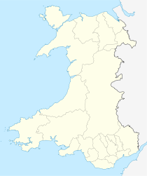
Ubicación dentro de Gales
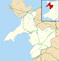
Localización de Llanbedr en Gwynedd
Ubicación dentro de Gwynedd
Entidad Localidad
 • País Bandera de Gales Gales
 • Estado soberano Bandera del Reino Unido Reino Unido
 • Área principal Gwynedd
 • Condado ceremonial Gwynedd
Población  
 • Total 1,005 hab.(incluye Llanfair y Llandanwg)
Prefijo telefónico 01341
Localidad postal HARLECH
Distrito postal LL46
Policía North Wales
Bomberos North Wales
Ambulancia Welsh

Llanbedr es un pueblo en el área de Ardudwy, condado de Gwynedd, Gales, Reino Unido.

El pueblo creció originalmente alrededor de las canteras de pizarra. Entre los atractivos de Llanbedr se encuentran menhires del Neolítico y cabañas circulares de la Edad del Bronce. Las dunas de Morfa Dyffryn y la Isla Mochras se encuentran en las cercanías. Cuenta con dos pubs: Ty Mawr Hotel y la Posada The Victoria.

A menos de dos km del pueblo está la aldea de Pentre Gwynfryn, la cual alberga la antigua capilla de Capel Salem. El interior de ésta se hizo famoso gracias al pintor Sydney Curnow Vosper quien pintó a un miembro de la congregación, Siân Owen, con el atuendo tradicional galés.[1]

Llanbedr posee un aeropuerto en desuso que, hasta 2004, fue operado por la Defence Evaluation and Research Agency (DERA) y QinetiQ como plataforma de despegue para vehículos aéreos no tripulados usados como objetivos de prueba por la RAF y otras fuerzas británicas.[2] Frente al aeropuerto está una de las dos unidades NACATC (National Air Cadets Adventure Training Centres) en el Reino Unido (la otra está en Windermere, Distrito de los Lagos, Inglaterra.)

Al norte del pueblo se encuentra la villa de Pensarn, situada en el estuario marino donde el río Artro desemboca en el mar de Irlanda. Aquí tienen su sede el Club de yates Llanbedr & Pensarn y el centro de actividades al aire libre Christian Mountain Centre.

En la entrada sur del pueblo está el antiguo complejo de la RAF de Maes Artro, que apareció en la serie paranormal de televisión Most Haunted.

En las afueras del pueblo existe una estación ferroviaria, antiguamente conocida como Talwrn Bach Halt, que forma parte de la línea Cambrian Line.


Referencias

  1. «Salem (1908) by Sydney Curnow Vosper (1866 - 1942)» (en inglés). Consultado el 4 de septiembre de 2011.
  2. Mills, Wendy (2002) Target Rolling: A History of Llanbedr Airfield 1941-2002, Hinckley, Leics: Midland Publishing ISBN 1-85780-136-9

Enlaces externos


Wikimedia foundation. 2010.

Игры ⚽ Поможем сделать НИР

Mira otros diccionarios:

  • Llanbedr — infobox UK place country = Wales welsh name= constituency welsh assembly= Dwyfor Meirionnydd map type= latitude= 52.82011 longitude= 4.10137 official name= Llanbedr unitary wales= Gwynedd lieutenancy wales= Gwynedd constituency westminster=… …   Wikipedia

  • Llanbedr — Original name in latin Llanbedr Name in other language Llanbedr State code GB Continent/City Europe/London longitude 52.81667 latitude 4.1 altitude 66 Population 0 Date 2011 07 31 …   Cities with a population over 1000 database

  • Llanbedr (disambiguation) — Llanbedr (literally, church of St Peter in English) may refer to: *Llanbedr in Gwynedd *Llanbedr Pont Steffan (the Welsh name for Lampeter) *Llanbedr y Cennin (in the Conwy valley) *Llanbedr Dyffryn Clwyd (in the Vale of Clwyd) * Llanbedr, near… …   Wikipedia

  • Llanbedr-y-Cennin — is a small village in Conwy county borough, Wales.It lies in the foothills on the western side of the Conwy valley, in North Wales. The river Conwy runs through the valley, running into the sea to the north, at the town of Conwy, which is about… …   Wikipedia

  • Llanbedr-Dyffryn-Clwyd — infobox UK place country =Wales welsh name= constituency welsh assembly= official name= Llanbedr Dyffryn Clywd latitude= 53.12 longitude= 03.28 unitary wales= Denbighshire lieutenancy wales= Clwyd constituency westminster= Clwyd West post town=… …   Wikipedia

  • Llanbedr railway station — Infobox UK station name=Llanbedr code=LBR manager=Arriva Trains Wales locale=Llanbedr. borough=Gwynedd platforms=1 start= lowusage0405 = 10,717 lowusage0506 = 10,170 lowusage0607 = 14,645Llanbedr railway station serves the village of Llanbedr in… …   Wikipedia

  • Llanbedr Airport — ] In May 2008, the Snowdonia Society, the Brecon Beacons Park Society and the Friends of Pembrokeshire National Park formed an alliance against the development of a new civilian airport at the site.… …   Wikipedia

  • Moel y Gaer, Llanbedr — For other places with the same name, see Moel y Gaer. View of Moel y Gaer from the south Moel y Gaer (Welsh for bald hill of the fortress ) is an Iron Age hill fort located on a western spur of the Clwydian Range, near the village of Llanbedr,… …   Wikipedia

  • Tal-y-bont, Conwy — Tal y Bont is a small village in Conwy county borough, Wales. It lies in the Conwy valley in North Wales, west of the River Conwy, on the B5106 road, six miles from Conwy to the north, and six miles from Llanrwst to the south.It lies adjacent to… …   Wikipedia

  • University of Wales, Lampeter — Infobox University name = University of Wales, Lampeter native name = Prifysgol Cymru, Llanbedr Pont Steffan motto = Gair Duw Goreu Dysg The word of God is the best teacher established = 1822 (Charter 1828) staff = 200 chancellor = HRH the Prince …   Wikipedia

Compartir el artículo y extractos

Link directo
Do a right-click on the link above
and select “Copy Link”