Rakhine

Rakhine

Rakhine

Rakhine
Arakan
Estado de Birmania
Bandera de Rakhine
Bandera
Escudo de Rakhine
Escudo
Situación de Rakhine
Capital Sittwe
Idioma oficial Birmano
Entidad Estado
 • País Flag of Myanmar.svg Birmania
Subdivisiones 3 distritos
Superficie  
 • Total 36.762 km²
Población  
 • Total 2.744.000 hab. (2000)¹


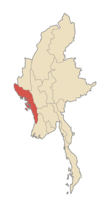
Rakhine (antiguamente Arakan) es un estado de Birmania. Situado en la costa oeste, limita con el Estado Chin al norte, la División de Magway, la de Bago y la de Ayeyarwady al este, el golfo de Bengala al oeste y la división de Chittagong, en Bangladesh al noroeste. La cadena montañosa de Arakan Roma que se eleva hasta los 3.063 m del Pico Victoria, separa el Estado Rakhine de Birmania propiamente dicha. La superficie del estado es de is 36.762 km² y su capital es Sittwe, antiguamente llamada Akyab. En 2000 se calculaba que la población era de 2.744.000 habitantes, básicamente de dos grupos étnicos: los Rakhine y los bengalíes. Las etnias restantes son los Mro, Khami/Khumi, musulmanes Kaman, Dienet, Marmagri y algunos otros. La mayor parte de la población es budista, siendo el islam la segunda religión.

Véase también

Obtenido de "Rakhine"

Wikimedia foundation. 2010.

Игры ⚽ Поможем сделать НИР

Mira otros diccionarios:

  • Rakhine — État d Arakan ရခိုင်ပြည်နယ် (État d Arakan) Drapeau de l État d Arakan …   Wikipédia en Français

  • Rakhine — Admin ASC 1 Code Orig. name Rakhine Country and Admin Code MM.01 MM …   World countries Adminstrative division ASC I-II

  • Rakhine State — ရခိုင်ပြည်နယ် Arakan State   State   Myanma transcription(s) …   Wikipedia

  • Rakhine people — Infobox Ethnic group group=Rakhine (Arakanese) poptime=3.5 4 million (est.) popplace=Myanmar, Eastern Bangladesh rels=Theravada Buddhism langs=Arakanese related=The Rakhine people (MYname|MY=ရခိုင္လူမ်ဳိး၊MLCTS=ra. khuing lu myo:; IPA2|ja̰kʰàin… …   Wikipedia

  • Rakhine State Cultural Museum — The Rakhine State Cultural Museum is a museum that display figurings of Rakhine races and their traditional dresses, traditional looms and arts of Rakhine people, models of stone inscriptions, musical instruments, coins, Buddha images, paintings …   Wikipedia

  • Rakhine Mountains — ▪ mountains, Myanmar Burmese  Rakhine Yoma,  also called  Arakan Mountains         mountain arc in western Myanmar (Burma), between the Rakhine (Arakan) coast and the Irrawaddy River valley. The arc extends northward for about 600 miles (950 km)… …   Universalium

  • Rakhine — ISO 639 3 Code : rki ISO 639 2/B Code : ISO 639 2/T Code : ISO 639 1 Code : Scope : Individual Language Type : Living …   Names of Languages ISO 639-3

  • History of Rakhine — The Rakhine people (Arakanese) claim a history that began in 2666 BC and certain archaeological evidence have been supposed to be found to support this claim. According to legend, the first independent kingdom was established in 2666 BC by King… …   Wikipedia

  • État de Rakhine — État d Arakan ရခိုင်ပြည်နယ် (État d Arakan) Drapeau de l État d Arakan …   Wikipédia en Français

  • Arakan (Rakhine) State —    One of Burma s 14 states and divisions, it has an area of 36,778 square kilometres (14,200 square miles) and a population estimated at 2.7 million in 2000 (1983 census figure: 2,045,559). Ethnically, the majority of the population are… …   Historical Dictionary of Burma (Myanmar)

Compartir el artículo y extractos

Link directo
Do a right-click on the link above
and select “Copy Link”